About This Experience
The ultimate Bay Area escape — a private full-day Jeep Wrangler journey to your choice of California's most iconic destinations. Route A: Yosemite National Park (April–October, 10–12 hrs). Route B: Muir Woods + Sausalito (year-round, 8–10 hrs). Route C: Big Sur / Highway 1 (dry season, 10–11 hrs). All routes include door-to-door pickup and complimentary refreshments throughout.
- All payments are final
- Door-to-door pickup
- Private group only
- Refreshments included
A Day in Yosemite, Muir Woods, or Big Sur — California's Most Iconic Escapes
This is the ultimate California day trip — a private, door-to-door Jeep Wrangler journey to one of three legendary destinations, each one a masterclass in what makes this state so endlessly compelling. Whether you choose the granite cathedrals of Yosemite, the ancient redwood silence of Muir Woods, or the cliff-edge drama of Highway 1 through Big Sur, your guide handles every mile so you can simply drink it all in.
Departure & Scenic Drive — Your Choice of Route
90 minThe early start is part of the magic — the Bay Area freeways give way to open highway as the city dissolves in the rearview mirror. Your guide sets the tone with local stories and context for the landscape ahead, whether you're heading east on I-580 toward the Central Valley, north across the Golden Gate Bridge on US-101, or south on Highway 1 toward the Santa Cruz Mountains. Complimentary coffee, cold drinks, and snacks are on hand throughout the journey.
Route A: Tunnel View, Yosemite National Park — OR — Route B: Muir Woods National Monument — OR — Route C: Bixby Creek Bridge, Big Sur
60 minFor Route A, you arrive at Tunnel View on Wawona Road — the single most photographed vista in Yosemite — where El Capitan, Half Dome, and Bridalveil Fall frame a valley that stops conversation cold. For Route B, you step beneath the cathedral canopy of old-growth coast redwoods along the Main Trail in Muir Woods, where some trees have stood for over 1,000 years. For Route C, you pull over at the iconic Bixby Creek Bridge on Highway 1, one of the highest single-span concrete bridges in the world, arching over a gorge that drops to a wild Pacific cove.
Route A: Valley Floor & Cook's Meadow Loop — OR — Route B: Sausalito Waterfront — OR — Route C: McWay Falls, Julia Pfeiffer Burns State Park
90 minIn Yosemite Valley, you stroll the Cook's Meadow Loop — a flat, easy path that puts Half Dome directly in front of you and Yosemite Falls tumbling down the valley wall to your left. In Sausalito, you wander the sun-warmed waterfront promenade along Bridgeway, browsing galleries and boutiques in one of the Bay Area's most charming villages. In Big Sur, a short trail through Julia Pfeiffer Burns State Park leads to the overlook above McWay Falls, where an 80-foot waterfall drops directly onto a pristine, inaccessible beach.
Route A: Yosemite Village & Ansel Adams Gallery — OR — Route B: Muir Beach Overlook — OR — Route C: Nepenthe Restaurant, Big Sur
75 minIn Yosemite Village, you browse the Ansel Adams Gallery on Village Drive, where fine prints of Adams's iconic Yosemite photographs share space with the very valley that inspired them — a rare and moving juxtaposition. At Muir Beach Overlook on Shoreline Highway, you stand on a bluff above a sweeping Pacific coastline that stretches from Stinson Beach to Point Reyes, the ocean enormous and silver below. At Nepenthe on Highway 1, you settle onto the legendary terrace 800 feet above the Pacific — a restaurant that has perched on this cliff since 1949 — for lunch with one of the most dramatic views in American dining.
Route A: Mirror Lake Trail & Tenaya Creek — OR — Route B: Stinson Beach & Bolinas Lagoon — OR — Route C: Pfeiffer Beach, Los Padres National Forest
90 minThe Mirror Lake Trail in Yosemite leads you along Tenaya Creek to a seasonal lake that reflects the sheer granite face of Half Dome in its still, clear water — a moment of near-perfect symmetry. Along Shoreline Highway, Stinson Beach offers a long, wild stretch of Pacific coastline backed by Mount Tamalpais, while Bolinas Lagoon shimmers alongside the road, often dotted with harbor seals and great blue herons. Pfeiffer Beach, reached via the narrow Sycamore Canyon Road off Highway 1, is a dramatic cove of purple-tinged sand — colored by manganese garnet in the cliffs — framed by sea stacks and crashing surf.
Route A: Glacier Point Road Viewpoint — OR — Route B: Mount Tamalpais East Peak Viewpoint — OR — Route C: Point Sur State Historic Park Overlook
60 minGlacier Point, reached via Glacier Point Road, delivers a 3,200-foot vertical view straight down into Yosemite Valley — Half Dome at eye level, the valley floor a patchwork of meadow and forest far below, and the High Sierra rolling away to the horizon. The East Peak of Mount Tamalpais, accessed via Ridgecrest Boulevard and East Ridgecrest Boulevard, offers a 360-degree panorama that takes in the Bay, the Pacific, the Golden Gate, and the green folds of Marin all at once. The Point Sur Lighthouse, perched on a volcanic rock promontory above Highway 1, has guided ships since 1889, and the overlook beside it frames a coastline of almost savage beauty.
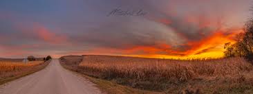
Sunset Stop & Final Reflection — Route Dependent
45 minAs the light softens and turns golden, your guide finds the finest late-afternoon vantage point on your chosen route — the meadows near Yosemite Valley's Sentinel Bridge with Half Dome catching the last warm light, the ridge above Muir Beach where the Pacific goes copper and rose, or a pull-off on Highway 1 south of Garrapata State Park where the cliffs glow amber above the darkening sea. This is the unhurried moment to breathe it all in, take a final photograph, and let the day settle. Your guide pours a last round of refreshments as the landscape does what it does best.
Guest Reviews
No reviews yet — be the first to share your experience!